OBSERVER: Using Copernicus to monitor activities and changes in the Arctic

OBSERVER: Using Copernicus to monitor activities and changes in the ArcticAnnekatrien Debien
Thu, 07/10/2021 – 13:13
The Arctic is a fascinating and complex geographical, meteorological and biological ecosystem whose impact is significant and far-reaching. From its busy shipping routes that connect the Atlantic and Pacific oceans to its role in regulating global temperatures, the Arctic is of direct importance to our daily lives in many ways.
The data and information of the Copernicus programme enable accurate monitoring of the ever-changing Arctic environment. The region is highly influenced by the impacts of climate change, while being rich in natural resources and home to an abundance of wildlife. Because of its vastness, obtaining information on activities and changes in the Arctic is often only possible using satellite imagery, in combination with climate and marine environment models and in situ measurements from its remote areas. The examples below give a brief insight into the wide range of potential Copernicus applications for the Arctic region.
Shipping in the Arctic
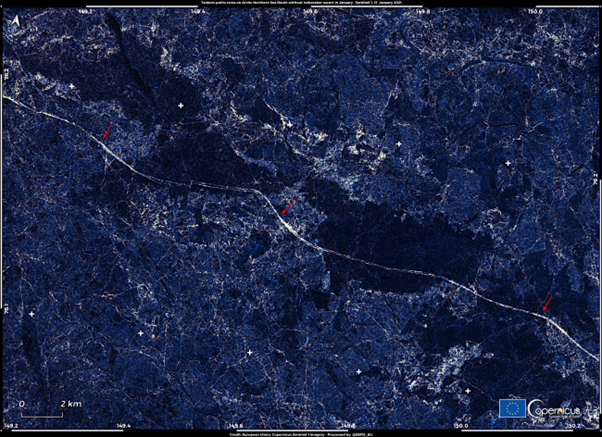
The most visible effect of climate change can be found in the Arctic sea ice, which is becoming thinner and retreating, opening up passages for ships to sail through the Northeast and Northwest Passages. Copernicus Sentinel-1 satellites provide useful of information about the development of ice conditions in the Arctic. For instance, the provision of data on sea ice helps to improve ship routing services, offshore operations and search and rescue operations, thus contributing to maritime safety.
This image, acquired by one of the Copernicus Sentinel-1 satellites on 13 January 2021, shows the path of one of the two LNG carriers, breaking the sea ice of the Arctic Ocean.
This image shows an example, of the night of 11 January 2021, when two icebreaking liquefied natural gas (LNG) carriers, the Christophe de Margerie and Nikolay Zubov, crossed paths in the Northern Arctic Ocean, taking advantage of the reduced thickness of the ice. This marked the first time that two tankers were able to sail (in opposite directions) the Northern Sea Route in January without icebreaker escort.
Carbon storage in Arctic peatlands
Peatlands are a type of wetland among the most valuable ecosystems on Earth: they are critical for preserving global biodiversity, providing safe drinking water, minimising flood risk and helping address climate change because they sequester 0.37 gigatonnes of carbon dioxide (CO2) a year – storing more carbon than all other vegetation types in the world combined.
A particular type of peatland can be found in the Arctic tundra, “frozen” mires in which large quantities of organic deposits remain frozen throughout the year. Their hydrological regime and other characteristics are strongly dependent on the status and health of the permafrost.
A recent study of the University of Stockholm found that, if the global warming scenarios are proven right, arctic peatlands will emit more carbon than they can store, because of the thawing of the permafrost, resulting in severe repercussions for the global climate.
This image acquired on 31 July by one of the Copernicus Sentinel-2 satellites shows a section of the Lena Delta, in Siberia, whose landscape is characteristic of Arctic tundra.
Marine productivity in the Arctic Ocean
At the peak of summer, phytoplankton blooms in the Barents Sea can extend for hundreds of kilometres. Their growth is favoured by the water stratification that occurs at this time of year.
The stratification of the waters occurs not only due to the high insolation but also because the Barents Sea is involved in the cooling process of the Arctic Ocean through the dissipation of heat from its surface waters.
According to a recent study published in the Nature scientific journal, the Barents Sea, in the future, will not be able to dissipate the heat carried towards the Arctic by the Gulf Stream as a consequence of climate change.
This image, acquired by one of the Copernicus Sentinel-3 satellites on 2 August 2021, shows a massive phytoplankton bloom in the Barents Sea.
Learn more about Copernicus and EU Space applications for the Arctic by participating in the CASSINI hackathon!
The second CASSINI Hackathon will focus on this extraordinary region, challenging you to develop ideas that help maintain safe passage at sea, assist life on land, and safeguard its native wildlife. With your help, we can protect, support and strengthen the Arctic using European space data, signals, and technologies from the EU Space Programme.
The CASSINI Hackathons and Mentoring, initiated by the European Union and its space programmes, is a series of six hackathons that tackle global challenges using European space technologies. Now in its second edition these hackathons provide access to pre-processed Arctic data, on-demand training, and other valuable tools to help participants take on one of our three challenges. The best ideas will be awarded at both local and EU levels, and the overall winners will gain entry into a six-month mentoring programme that includes 100 hours of customised expert mentoring.
Now is your chance to become part of this exciting European initiative to promote EU Space technology and its many applications. Hack with a purpose and leverage EU space data, services and signals to access, understand and protect the Arctic! More information: hackathons.cassini.eu
Thu, 07/10/2021 – 12:00


